Raymond, New Hampshire | |
|---|---|
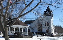
 The Common (Lyman Memorial Park), 2013 | |
 Location in Rockingham County and the state of New Hampshire. | |
| Coordinates: 43°02′10″N 71°11′00″W / 43.03611°N 71.18333°W | |
| Country | United States |
| State | New Hampshire |
| County | Rockingham |
| Incorporated | 1764 |
| Government | |
| • Board of Selectmen |
|
| • Town Manager | Ken Robichaud |
| Area | |
• Total | 29.6 sq mi (76.7 km2) |
| • Land | 28.8 sq mi (74.6 km2) |
| • Water | 0.8 sq mi (2.1 km2) 2.68% |
| Elevation | 200 ft (60 m) |
| Population (2020) | |
• Total | 10,684 |
| • Density | 371/sq mi (143.1/km2) |
| Time zone | UTC-5 (Eastern) |
| • Summer (DST) | UTC-4 (Eastern) |
| ZIP code | 03077 |
| Area code | 603 |
| FIPS code | 33-64020 |
| GNIS feature ID | 0873705 |
| Website | www |
Raymond is a town in Rockingham County, New Hampshire, United States. The population was 10,684 at the 2020 census.[2] Part of Pawtuckaway State Park is in the north.
The main village in town, where 3,738 people resided at the 2020 census,[3] is defined as the Raymond census-designated place (CDP), and is located along the Lamprey River near New Hampshire Route 27.
- ^ "2021 U.S. Gazetteer Files – New Hampshire". United States Census Bureau. Retrieved January 3, 2022.
- ^ "Census - Geography Profile: Raymond town, Rockingham County, New Hampshire". United States Census Bureau. Retrieved December 24, 2021.
- ^ "Census - Geography Profile: Raymond CDP, New Hampshire". United States Census Bureau. Retrieved December 24, 2021.
