 NASA picture of Reao Atoll | |
| Geography | |
|---|---|
| Location | Pacific Ocean |
| Coordinates | 18°28′11″S 136°26′33″W / 18.46972°S 136.44250°W |
| Archipelago | Tuamotus |
| Area | 34 km2 (13 sq mi) (lagoon) 9 km2 (3 sq mi) (above water) |
| Length | 24.5 km (15.22 mi) |
| Width | 5 km (3.1 mi) |
| Administration | |
France | |
| Overseas collectivity | French Polynesia |
| Administrative subdivision | Tuamotus |
| Commune | Reao |
| Demographics | |
| Population | 305[1] (2022) |
Reao | |
|---|---|
 | |
| Coordinates: 18°28′11″S 136°26′33″W / 18.4697°S 136.4426°W | |
| Country | France |
| Overseas collectivity | French Polynesia |
| Subdivision | Îles Tuamotu-Gambier |
| Area 1 | 18 km2 (7 sq mi) |
| Population (2022)[1] | 513 |
| • Density | 29/km2 (74/sq mi) |
| Time zone | UTC−10:00 |
| INSEE/Postal code | 98742 / |
| Elevation | 0 m (0 ft) |
| 1 French Land Register data, which excludes lakes, ponds, glaciers > 1 km2 (0.386 sq mi or 247 acres) and river estuaries. | |
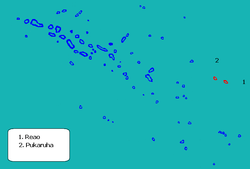
Reao or Natūpe is an atoll in the eastern expanses of the Tuamotu group in French Polynesia. The closest land is Pukarua Atoll, located 48 km to the WNW.
Reao is 24.5 km long and its maximum width is 5 km. The whole length of its north-eastern rim is occupied by a single long island. There is no navigable pass into the lagoon.
Reao Atoll's population is 305 inhabitants (2022).[1]
- ^ a b c "Les résultats du recensement de la population 2022 de Polynésie française" [Results of the 2022 population census of French Polynesia] (PDF) (in French). Institut de la statistique de la Polynésie française. January 2023.


