 | |
 | |
| Former names | Columbia Park (1866–1875), Centennial Park (1875–1883) |
|---|---|
| Location | Philadelphia, Pennsylvania |
| Coordinates | 39°58′56″N 75°10′29″W / 39.98222°N 75.17472°W |
| Capacity | 6,500 |
| Field size | Left – 300 ft. Center – 331 ft. |
| Surface | Grass |
| Construction | |
| Opened | In use by at least 1860. |
| Closed | 1886 |
| Demolished | C. 1890 |
| Tenants | |
| Philadelphia Athletics (NA) (1861-1870) Philadelphia Pythians (1865-1871) Philadelphia Centennials (NA) (1875) Philadelphia Phillies (NL) (1883-1886) | |
Recreation Park was a baseball park in Philadelphia.
The ballpark was the first home of the Philadelphia Phillies of the National League during the years 1883–1886, prior to the opening of the ballpark that became known as Baker Bowl.
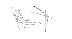
The park was bounded by 24th Street (east, first base); Ridge Avenue (north, right field); Montgomery Avenue (northwest, center field); 25th Street (west, left field); and Columbia Avenue (south, third base) (which in 1987 was renamed Cecil B. Moore Avenue after the civil-rights leader). The park was not the only one in the area; 14 years later, Columbia Park, the first home of the Philadelphia Athletics, opened eight blocks to the west on Columbia Avenue, across the avenue to the south.