| Red River Gorge Geological Area | |
|---|---|
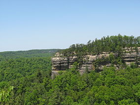
 Chimney Top Rock | |
| Location | Slade, Kentucky, United States |
| Coordinates | 37°50′2″N 83°36′28″W / 37.83389°N 83.60778°W |
| Area | 29,000 acres (120 km2)[1] |
| Established | February 1937[2] |
| Governing body | United States Forest Service |
| www | |
| Designated | 1975 |
The Red River Gorge is a canyon system on the Red River in east-central Kentucky, United States. Geologically it is part of the Pottsville Escarpment.
The gorge lies within the Daniel Boone National Forest and was subsequently designated the Red River Gorge Geological Area, an area of around 29,000 acres (12,000 ha; 120 km2; 45 sq mi).[1] It was designated a National Natural Landmark and National Archaeological District, and listed on the National Register of Historic Places.[3] The 13,379-acre (5,414 ha; 54.14 km2; 20.905 sq mi)[4] Clifty Wilderness Area lies entirely within the geological area in the Red River Gorge.
This intricate canyon system features an abundance of high sandstone cliffs, rock shelters, waterfalls, and natural bridges. There are more than 100 natural sandstone arches in the Red River Gorge Geological Area. The multitude of sandstone and cliff-lines helped this area become one of the world's top rock climbing destinations and is home to the Red River Gorge Climbers' Coalition. The area is nicknamed the Red by climbers.[5]
Kentucky's Natural Bridge State Park is immediately adjacent to this area, featuring one of the largest natural bridges in the Red River Gorge.
The section of the Red River in the upper gorge is also a legally designated Kentucky Wild River by the Kentucky General Assembly through the Office of Kentucky Nature Preserves' Wild Rivers Program.
Because of its unusual and rugged nature, the Red River Gorge features a remarkable variety of ecological zones.


- ^ a b "Red River Gorge Hiking and Camping News and Views". Retrieved May 2, 2013.
- ^ "Daniel Boone National Forest - About the Forest". Retrieved May 2, 2013.
- ^ "Red River Gorge Geological Area". U.S. Forest Service.
- ^ "Wilderness Acreage Breakdown for the Clifty Wilderness".
- ^ Pegg, Dave. Red River Gorge, Kentucky, USA, UK Climbing, March 2009.
