Redland, Florida | |
|---|---|
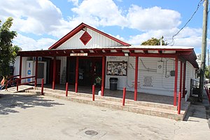
 The 1912 Pioneer Guild Hall in Redland, now the Redland Grocery | |
| Coordinates: 25°31′42″N 80°29′25″W / 25.5284426°N 80.4903347°W | |
| Country | United States |
| State | Florida |
| County | Miami-Dade |
| Government | |
| • Governing body | Miami-Dade County |
| • Mayor | Daniella Levine Cava |
| Elevation | 7 ft (2 m) |
| Population (2010[1]) | |
| • Total | 10,138[specify] |
| Time zone | UTC-5 (Eastern (EST)) |
| • Summer (DST) | UTC-4 (EDT) |
| Area code(s) | 305, 786 |
| FIPS code | 12-36100[2] |
| GNIS feature ID | 0285050[3] |
Redland, long known also as the Redlands[4][5][6] or the Redland,[7] is a historic unincorporated community and agricultural area in Miami-Dade County, Florida, located about 20 miles (32 km) southwest of downtown Miami and just northwest of Homestead, Florida. It is unique in that it constitutes a large farming belt directly adjoining what is now the seventh most populous major metropolitan area in the United States.[8] Named for the pockets of red clay that cover a layer of oolitic limestone,[9] Redland produces a variety of tropical fruits, many of which do not grow elsewhere in the continental United States.[10] The area also contains a large concentration of ornamental nurseries.[9] The landscape is dotted with u-pick'em fields, coral rock (oolite) walls, and the original clapboard homes of early settlers and other historic early twentieth century structures.
- ^ 2010 United States Census
- ^ "U.S. Census website". United States Census Bureau. Retrieved January 31, 2008.
- ^ "US Board on Geographic Names". United States Geological Survey. October 25, 2007. Retrieved January 31, 2008.
- ^ Landsel, David (December 11, 2006). "MUSTS: Simply Red". New York Post. Retrieved February 5, 2020.
- ^ "Bank of Homestead - "Banking Service for the Redlands" (advertisement)". Homestead Leader. January 10, 1929. p. 8. Retrieved February 5, 2020.
- ^ "Aladdin City and the Redlands (advertisement)". Homestead Leader. February 25, 1926. p. 6. Retrieved February 25, 2020.
- ^ "Edible Guide to Homestead & the Redland". ediblecommunities.com. Edible South Florida. January 1, 2015. Retrieved March 10, 2020.
- ^ Nebhrajani, Roshan (December 11, 2016). "A brief history of South Dade". newtropic.com. New Tropic. Retrieved March 12, 2020.
- ^ a b Veciana-Suárez, Ana (December 19, 2014). "In Redland, you'll find a taste of country". Miami Herald. Retrieved February 17, 2020.
- ^ Winerman, Lea (February 23, 2012). "The Impulsive Traveler: In Florida, a taste of tropical fruits". Washington Post. Retrieved February 17, 2020.

