| Redwood River | |
|---|---|
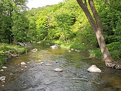
 The Redwood River in Camden State Park in 2007 | |
 | |
| Location | |
| Country | United States |
| State | Minnesota |
| Physical characteristics | |
| Source | |
| • location | Aetna Township, Pipestone County |
| • coordinates | 44°10′03″N 96°10′18″W / 44.16750°N 96.17167°W[1] |
| • elevation | 1,909 ft (582 m)[2] |
| Mouth | Minnesota River |
• location | near Redwood Falls, Redwood County |
• coordinates | 44°34′16″N 95°05′18″W / 44.57111°N 95.08833°W[1] |
• elevation | 827 ft (252 m)[2] |
| Length | 127.1 mi (204.5 km)[3] |
| Basin size | 705 sq mi (1,830 km2)[4] |
| Discharge | |
| • location | near Redwood Falls[5] |
| • average | 153 cu ft/s (4.3 m3/s)[5] |
| • minimum | 0 cu ft/s (0 m3/s) |
| • maximum | 19,700 cu ft/s (560 m3/s) |
| Discharge | |
| • location | near Marshall[6] |
| • average | 69.5 cu ft/s (1.97 m3/s)[6] |
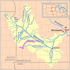
The Redwood River is a tributary of the Minnesota River, 127 miles (204 km) long, in southwestern Minnesota in the United States. Via the Minnesota River, it is part of the watershed of the Mississippi River, draining an area of 705 square miles (1,830 km2) in an agricultural region. The river's name is believed to refer to the reddish bark of dogwood growing along streams in the region.[7]
- ^ a b "Geographic Names Information System entry for Redwood River (Feature ID #658010)". Geographic Names Information System. Retrieved 2007-06-03.
- ^ a b Google Earth elevation for GNIS coordinates. Retrieved on 2007-06-03.
- ^ "Redwood River Major Watershed". Minnesota River Basin Data Center. Minnesota State University, Mankato. 2000-06-06. pp. Streams within the Redwood River Major Watershed. Retrieved 2007-06-03.
- ^ "Redwood River Major Watershed". Minnesota River Basin Data Center. Minnesota State University, Mankato. 2000-06-06. pp. General Description. Retrieved 2007-06-03.
- ^ a b Mitton, G. B.; K. G. Guttormson; G. W. Stratton; E. S. Wakeman. "Water Resources Data in Minnesota, Water Year 2005 Annual Report". United States Geological Survey. pp. Redwood River near Redwood Falls, MN. Retrieved 2007-06-03.
- ^ a b Cite error: The named reference
USGSmwas invoked but never defined (see the help page). - ^ Waters, Thomas F. (2006). "The Southwest: Rivers of the Coteau des Prairies". The Streams and Rivers of Minnesota. Minneapolis: University of Minnesota Press. pp. 288–303. ISBN 0-8166-0960-8.