Rehoboth, Massachusetts | |
|---|---|
 Goff Memorial Hall | |
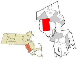
 Location in Bristol County in Massachusetts | |
| Coordinates: 41°50′25″N 71°15′00″W / 41.84028°N 71.25000°W | |
| Country | United States |
| State | Massachusetts |
| County | Bristol |
| Settled | 1643 |
| Incorporated | 1645 |
| Government | |
| • Type | Open town meeting |
| Area | |
| • Total | 46.8 sq mi (121.1 km2) |
| • Land | 46.5 sq mi (120.4 km2) |
| • Water | 0.3 sq mi (0.7 km2) |
| Elevation | 50 ft (15 m) |
| Population (2020) | |
| • Total | 12,502 |
| • Density | 270/sq mi (100/km2) |
| Time zone | UTC-5 (Eastern) |
| • Summer (DST) | UTC-4 (Eastern) |
| ZIP Code | 02769 |
| Area code | 508/774 |
| FIPS code | 25-56375 |
| GNIS feature ID | 0619437 |
| Website | www.town.rehoboth.ma.us |
Rehoboth is a historic town in Bristol County, Massachusetts, United States. Established in 1643, Rehoboth is one of the oldest towns in Massachusetts. The population was 12,502 at the 2020 census.[1] Rehoboth is a mostly rural community with many historic sites, including 53 historic cemeteries.
- ^ "Census - Geography Profile: Rehoboth town, Massachusetts". United States Census Bureau. Retrieved November 11, 2021.
