| Reid Canberra, Australian Capital Territory | |||||||||||||||
|---|---|---|---|---|---|---|---|---|---|---|---|---|---|---|---|
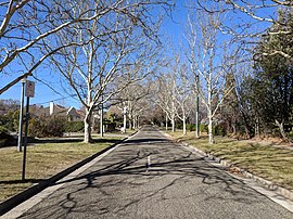
 Dirrawan Gardens in July 2018 | |||||||||||||||
| Coordinates | 35°17′0″S 149°08′30″E / 35.28333°S 149.14167°E | ||||||||||||||
| Population | 1,544 (2021 census)[1] | ||||||||||||||
| • Density | 441/km2 (1,143/sq mi) | ||||||||||||||
| Established | 1928 | ||||||||||||||
| Postcode(s) | 2612 | ||||||||||||||
| Elevation | 570 m (1,870 ft) | ||||||||||||||
| Area | 3.5 km2 (1.4 sq mi) | ||||||||||||||
| Location |
| ||||||||||||||
| District | North Canberra | ||||||||||||||
| Territory electorate(s) | Kurrajong | ||||||||||||||
| Federal division(s) | Canberra | ||||||||||||||
| |||||||||||||||
Reid is a suburb of Canberra, Australian Capital Territory, Australia. With a population of 1,544 at the 2021 census,[1] located directly next to Civic, Reid is one of the oldest suburbs in Canberra. It is named after George Reid, the fourth prime minister of Australia.
Separating the suburbs of Reid and Campbell is Anzac Parade, a ceremonial boulevarde running along Canberra's primary design axis (the land axis) from Lake Burley Griffin to the Australian War Memorial.
Located in Reid are the Canberra Institute of Technology and St John the Baptist Church, which is the oldest church in Canberra.
- ^ a b Australian Bureau of Statistics (28 June 2022). "Reid". 2021 Census QuickStats. Retrieved 14 July 2022.
