| Resting Spring Range | |
|---|---|
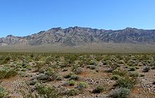
 The Resting Spring Range as viewed from Pahrump, Nevada | |
| Highest point | |
| Peak | 13667 |
| Coordinates | 36°04′38″N 116°13′57″W / 36.07722°N 116.23250°W[1] |
| Geography | |
location of Resting Spring Range in California[2] | |
| Country | United States |
| State | California |
| District | Inyo County |
| Range coordinates | 36°05′00″N 116°14′03″W / 36.08333°N 116.23417°W |
| Topo map | USGS Twelvemile Spring |
The Resting Spring Range is found in the eastern Mojave Desert of California near the Nevada state line in the United States. The range lies in a generally north–south direction to the west of the Nopah Range and southeast of the Amargosa Range and Greenwater Range.
The mountains in Inyo County, California, lie between the Amargosa River and California State Route 127 to the west and Stewart and Chicago valleys and California State Route 178 to the east.[3]

- ^ Twelve Mile Springs, CA, 7.5 Minute Topographic Quadrangle, USGS, 1984
- ^ "Resting Spring Range". Geographic Names Information System. United States Geological Survey, United States Department of the Interior. Retrieved 2009-05-04.
- ^ California Atlas & Gazetteer, DeLorme, 4th ed. 2015, p 109-110 ISBN 0899333834
