Richland County | |
|---|---|
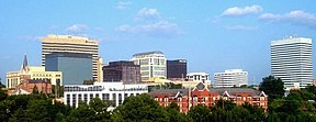
Skyline of Columbia Richland County Justice Center | |
| Motto: "Uniquely Urban...Uniquely Rural" | |
 Location within the U.S. state of South Carolina | |
 South Carolina's location within the U.S. | |
| Coordinates: 34°02′N 80°54′W / 34.03°N 80.90°W | |
| Country | |
| State | |
| Founded | March 12, 1785 |
| Named for | The county's "rich land"[1] |
| Seat | Columbia |
| Largest community | Columbia |
| Area | |
| • Total | 771.96 sq mi (1,999.4 km2) |
| • Land | 757.28 sq mi (1,961.3 km2) |
| • Water | 14.68 sq mi (38.0 km2) 1.90% |
| Population (2020) | |
| • Total | 416,147 |
| • Estimate (2023) | 425,138 |
| • Density | 549.53/sq mi (212.17/km2) |
| Time zone | UTC−5 (Eastern) |
| • Summer (DST) | UTC−4 (EDT) |
| Congressional districts | 2nd, 6th |
| Website | www |
Richland County is a county located in the U.S. state of South Carolina. As of the 2020 census, its population was 416,147,[2] making it the second-most populous county in South Carolina, behind only Greenville County. The county seat and largest community is Columbia,[3] the state capital. The county was established on March 12, 1785.[4] Richland County is part of the Columbia, SC Metropolitan Statistical Area. In 2020, the center of population of South Carolina was located in Richland County, in the city of Columbia.[5] The county is also the location of the geographic center of South Carolina, southeast of Columbia.[6]
- ^ "About Richland County". www.richlandcountysc.gov. Retrieved June 13, 2022.
- ^ Cite error: The named reference
2020CensusQuickFactswas invoked but never defined (see the help page). - ^ "Find a County". National Association of Counties. Archived from the original on May 31, 2011. Retrieved June 7, 2011.
- ^ "South Carolina - Legislative Acts Creating Counties / Districts". South Carolina General Assembly. 1785. Retrieved March 20, 2022.
- ^ "2020 Centers of Population by State". United States Census Bureau. November 16, 2021. Retrieved October 25, 2023.
- ^ "Geographic Centers of the United States" (PDF). pubs.usgs.gov. September 3, 2011. Retrieved October 25, 2023.


