Richland Parish | |
|---|---|
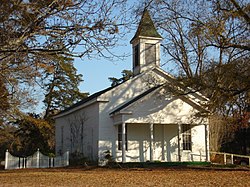
 Alto Presbyterian Church | |
 Location within the U.S. state of Louisiana | |
 Louisiana's location within the U.S. | |
| Coordinates: 32°25′18″N 91°45′43″W / 32.421736°N 91.762070°W | |
| Country | |
| State | |
| Founded | September 29, 1878 |
| Named for | Fertile (rich) land in the area |
| Seat | Rayville |
| Largest town | Rayville |
| Area | |
| • Total | 576 sq mi (1,490 km2) |
| • Land | 559 sq mi (1,450 km2) |
| • Water | 9.375 sq mi (24.28 km2) 1.6% |
| Population (2020) | |
| • Total | 20,043 |
| • Density | 35/sq mi (13/km2) |
| Time zone | UTC−6 (Central) |
| • Summer (DST) | UTC−5 (CDT) |
Richland Parish is a parish located in the North Louisiana Delta Country in the U.S. state of Louisiana, known for its fertile, flat farmland, cane brakes, and open spaces. The parish had a population of 20,043 at the 2020 United States census.[1] The name Richland was chosen due to the rich production from farming. The parish seat and largest community is Rayville.
- ^ "Census - Geography Profile: Richland Parish, Louisiana". Retrieved January 22, 2023.