Richmond District
Park-Presidio District (1917–2009) | |
|---|---|
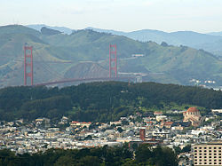
 San Francisco's Richmond District in foreground, with Golden Gate Bridge, Marin Headlands, and the Presidio in background | |
| Nickname(s): The Richmond, The Avenues | |
| Coordinates: 37°46′40″N 122°28′58″W / 37.77778°N 122.48278°W | |
| Country | |
| State | |
| City and county | San Francisco |
| Named for | Richmond, Victoria, Australia |
| Government | |
| • Supervisor | Connie Chan |
| • Assemblymember | Phil Ting (D)[1] |
| • State Senator | Scott Wiener (D)[1] |
| • U. S. Repr. | Nancy Pelosi (D)[2] |
| Area | |
| • Total | 2.705 sq mi (7.01 km2) |
| • Land | 2.705 sq mi (7.01 km2) |
| Population | |
| • Total | 59,297 |
| • Density | 21,920/sq mi (8,460/km2) |
| Time zone | UTC−8 (Pacific) |
| • Summer (DST) | UTC−7 (PDT) |
| ZIP codes | 94118, 94121 |
| Area codes | 415/628 |
| [3] | |
The Richmond District is a neighborhood in the northwest corner of San Francisco, California, developed initially in the late 19th century. It is sometimes confused with the city of Richmond, which is 20 miles (32 km) northeast of San Francisco; accordingly, the neighborhood usually is referred to as "the Richmond."
The Richmond is bordered by Golden Gate Park on the south, the Pacific Ocean to the west, and Lincoln Park, Mountain Lake Park and the Presidio of San Francisco to the north, bisected by the Presidio Greenbelt.
- ^ a b "Statewide Database". UC Regents. Retrieved December 29, 2014.
- ^ "California's 11th Congressional District - Representatives & District Map". Civic Impulse, LLC.
- ^ Richmond District from city-data.com
