Riggins, Idaho | |
|---|---|
| Motto: "Idaho's Whitewater Capital"[1] | |
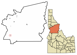
 Location of Riggins in Idaho County, Idaho. | |
| Coordinates: 45°25′20″N 116°18′57″W / 45.42222°N 116.31583°W | |
| Country | United States |
| State | Idaho |
| County | Idaho |
| Area | |
| • Total | 0.45 sq mi (1.15 km2) |
| • Land | 0.40 sq mi (1.03 km2) |
| • Water | 0.05 sq mi (0.12 km2) |
| Elevation | 1,821 ft (555 m) |
| Population | |
| • Total | 419 |
| • Estimate (2019)[4] | 416 |
| • Density | 1,045.23/sq mi (403.92/km2) |
| Time zone | UTC-7 (Mountain) |
| • Summer (DST) | UTC-6 (Mountain) |
| ZIP code | 83549 |
| Area code | 208 |
| FIPS code | 16-67870 |
| GNIS feature ID | 0389360 |
| Website | www |
Riggins is a city in the western United States in Idaho County, Idaho. Nestled deep in a canyon at the confluence of the Salmon and Little Salmon rivers in west central Idaho, it is approximately 150 highway miles (240 km) north of Boise, and 120 highway miles (190 km) south-southeast of Lewiston. The elevation is 1,821 feet (555 m) above sea level, and its population was 419 at the 2010 census.
U.S. Route 95, the only highway for the state connecting the Panhandle to the south, runs through Riggins as Main Street. Along this route, Riggins is the most northwestern town in the Mountain time zone; Pacific time begins just north of the city, across the Salmon River.[5][6]
- ^ "Riggins Chamber of Commerce". Riggins Chamber of Commerce. Retrieved September 2, 2012.
- ^ "2019 U.S. Gazetteer Files". United States Census Bureau. Retrieved July 9, 2020.
- ^ Cite error: The named reference
wwwcensusgovwas invoked but never defined (see the help page). - ^ Cite error: The named reference
USCensusEst2019CenPopScriptOnlyDirtyFixDoNotUsewas invoked but never defined (see the help page). - ^ "Time Zone Bridge over Salmon River heading west". Spokesman-Review. Associated Press. May 19, 1997. p. A7.
- ^ Johnson, David (June 21, 1997). "Time (zone) marches on". Lewiston Morning Tribune. p. 1A.