Rikuzentakata
陸前高田市 | |
|---|---|
City | |
 New Rikuzentakata City Hall | |
 Location of Rikuzentakata in Iwate Prefecture | |
| Coordinates: 39°01′40.9″N 141°37′31.5″E / 39.028028°N 141.625417°E | |
| Country | Japan |
| Region | Tōhoku |
| Prefecture | Iwate |
| Government | |
| • -Mayor | Toba Futoshi |
| Area | |
| • Total | 231.94 km2 (89.55 sq mi) |
| Population (October 10, 2020) | |
| • Total | 18,262 |
| • Density | 79/km2 (200/sq mi) |
| Time zone | UTC+9 (Japan Standard Time) |
| Phone number | 0192-54-2111 |
| Climate | Cfa |
| Website | Official website |
| Symbols | |
| Bird | Common gull |
| Flower | Camellia |
| Tree | Cryptomeria |

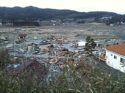
Rikuzentakata (陸前高田市, Rikuzentakata-shi) is a city located in Iwate Prefecture, Japan. In the census of 2010, the city had a population of 23,302 (2005: 24,709),[1] and a population density of 100 persons per km2. The 2011 Tōhoku earthquake and tsunami caused extensive damage to the city. As of 31 March 2020[update], the city had an estimated population of 19,062, and a population density of 82 persons per km2 in 7,593 households.[2] The total area of the city is 231.94 square kilometres (89.55 sq mi).[3]
- ^ "2010 census". Ministry of Internal Affairs and Communications. Retrieved 29 April 2011.
- ^ Rikuzentakata city official statistics(in Japanese)
- ^ 詳細データ 岩手県紫波町. 市町村の姿 グラフと統計でみる農林水産業 (in Japanese). Ministry of Agriculture, Forestry and Fisheries. 2016. Retrieved 13 April 2017.


