This article provides insufficient context for those unfamiliar with the subject. (June 2015) |
| Kathmandu Ring Road | ||||
|---|---|---|---|---|
| राष्ट्रिय राजमार्ग ३९ | ||||
| National Highway 39 | ||||
Kathmandu Ring Road in red | ||||
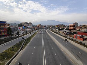
 Ring road at Dhobighat, Lalitpur | ||||
| Route information | ||||
| Maintained by MoPIT (Department of Roads) | ||||
| Length | 27 km (17 mi) | |||
| Existed | 1977–present | |||
| Major junctions | ||||
| Ring road around Kathmandu | ||||
| Balaju, Narayan Gopal Chowk, Chabahil, Gaushala, Tinkune, Koteshwor, Satdobato, Ekantkuna, Kalanki, Gongbu, | ||||
| Location | ||||
| Country | Nepal | |||
| Provinces | Bagmati Province | |||
| Districts | Kathmandu District and Lalitapur District | |||
| Highway system | ||||
| ||||


Kathmandu Ring Road or NH39 (previously: H16) (Nepali: काठमाडौं चक्रपथ) is an eight-lane ring road circling around the cities of Kathmandu and Lalitpur. The total length of the Ring Road is 27 kilometres (17 mi).[1] It has a right of way of 62m (with 31m on either side of the center line).
- ^ "Make Ring Road pedestrian-friendly". thehimalayantimes.com. The Himalayan Times.

