| Rio Chama | |
|---|---|
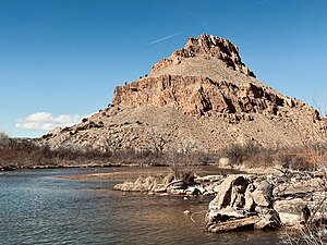
 The Rio Chama near Abiquiú, New Mexico | |
 Map of the Rio Chama within New Mexico, showing reservoirs and "wild and scenic" stretch | |
| Location | |
| Country | United States |
| State | New Mexico, Colorado |
| Counties | Rio Arriba County, New Mexico, Archuleta County, Colorado, Conejos County, Colorado |
| Physical characteristics | |
| Source | Confluence of West Fork and East Fork |
| • location | San Juan Mountains, Rio Grande National Forest, Colorado |
| • coordinates | 37°05′36″N 106°33′06″W / 37.09333°N 106.55167°W[1] |
| • elevation | 9,440 ft (2,880 m)[2] |
| Mouth | Rio Grande |
• location | San Juan Indian Reservation, New Mexico |
• coordinates | 36°2′32″N 106°5′16″W / 36.04222°N 106.08778°W[1] |
• elevation | 5,620 ft (1,710 m)[1] |
| Length | 130 mi (210 km)[3] |
| Basin size | 3,144 sq mi (8,140 km2)[4] |
| Discharge | |
| • location | USGS gage 08290000, 2.8 miles above mouth[4] |
| • average | 571 cu ft/s (16.2 m3/s)[4] |
| • minimum | 1.2 cu ft/s (0.034 m3/s) |
| • maximum | 15,000 cu ft/s (420 m3/s) |
| Type | Wild, Scenic |
| Designated | November 7, 1988 |
The Rio Chama, a major tributary river of the Rio Grande, is located in the U.S. states of Colorado and New Mexico. The river is about 130 miles (210 km) long altogether. From its source to El Vado Dam its length is about 50 miles (80 km), from El Vado Dam to Abiquiu Dam is about 51 miles (82 km), and from Abiquiu Dam to its confluence with the Rio Grande is about 34 miles (55 km).[3]
The name "Chama" is a shortened version of the Tewa term tsąmą' ǫŋwįkeyi, meaning "wrestling pueblo-ruin".[5][6]
- ^ a b c U.S. Geological Survey Geographic Names Information System: Rio Chama
- ^ Chama Peak, Colorado, 7.5 Minute Topographic Quadrangle, USGS, 1957 (1974 rev.)
- ^ a b Calculated in Google Earth
- ^ a b c "Water resources data for the United States, Water Year 2009; gage 08290000, Rio Chama near Chamita, NM" (PDF). USGS. Retrieved 21 July 2010.
- ^ Bright, William (2004). Native American placenames of the United States. University of Oklahoma Press. p. 87. ISBN 978-0-8061-3598-4. Retrieved 11 April 2011.
- ^ The namesake pueblo ruin is at 36°11′43″N 106°12′52″W / 36.1953174°N 106.2145758°W