Ripley, New York | |
|---|---|
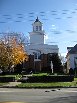
 Church in Ripley | |
| Motto: "The Gateway to New York State" | |
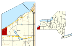
 Location in Chautauqua County and the state of New York. | |
| Coordinates: 42°15′42″N 79°41′53″W / 42.26167°N 79.69806°W | |
| Country | United States |
| State | New York |
| County | Chautauqua |
| Government | |
| • Type | Town Council |
| • Town Supervisor | Douglas Bowen |
| • Town Council | Members' List |
| Area | |
| • Total | 48.87 sq mi (126.57 km2) |
| • Land | 48.76 sq mi (126.30 km2) |
| • Water | 0.10 sq mi (0.27 km2) |
| Elevation | 1,299 ft (396 m) |
| Population | |
| • Total | 2,310 |
| • Estimate (2021)[2] | 2,292 |
| • Density | 47.60/sq mi (18.38/km2) |
| Time zone | UTC-5 (Eastern (EST)) |
| • Summer (DST) | UTC-4 (EDT) |
| ZIP code | 14775 |
| Area code | 716 |
| FIPS code | 36-013-61885 |
| GNIS feature ID | 0979424 |
| Website | www |
Ripley is a town on Lake Erie in the westernmost part of Chautauqua County, New York, United States. The population was 2,310 at the time of the 2020 census.[2] The town was named after Eleazer Wheelock Ripley, a general in the War of 1812. There are no incorporated villages in the town, but there is one census-designated place: the hamlet of Ripley. The town is perhaps best known as being the western terminus of the New York State Thruway.
- ^ "2016 U.S. Gazetteer Files". United States Census Bureau. Retrieved July 4, 2017.
- ^ a b c Bureau, US Census. "City and Town Population Totals: 2020-2021". Census.gov. US Census Bureau. Retrieved July 4, 2022.
{{cite web}}:|last1=has generic name (help)