| River Anker | |
|---|---|
 Alders Mill on the River Anker near Pinwall | |
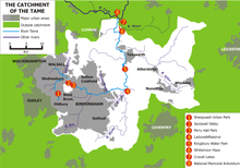
 Course and catchment of the River Anker, shown on the eastern side of the Tame catchment | |
| Location | |
| Country | England |
| Counties | Leicestershire, Warwickshire, Staffordshire |
| Towns | Nuneaton, Tamworth |
| Physical characteristics | |
| Source | |
| • location | Wolvey, Warwickshire |
| • coordinates | 52°28′33″N 1°20′50″W / 52.47590°N 1.34728°W |
| Mouth | River Tame |
• location | Tamworth, Staffordshire |
• coordinates | 52°37′53″N 1°41′52″W / 52.6315°N 1.6977°W |
| Length | 50 km (31 mi) |
| Discharge | |
| • location | Polesworth |
| • average | 3.2 m3/s (110 cu ft/s) |
| Basin features | |
| Tributaries | |
| • left | Penmire Brook, Innage Brook, River Sence, Griff Brook |
| • right | Wem Brook, Sketchley Brook |
The River Anker flows through Nuneaton, England. It is a major tributary of the River Tame, which it joins in Tamworth. The name derives from the old British for winding river.[1] From source to river mouth at Tamworth is 50 kilometres (31 mi).[2][3][4]
- ^ Ekwall, Eilert (1960). The concise Oxford dictionary of English place-names (4 ed.). Oxford: Clarendon Press. p. 10. OCLC 400936.
- ^ "Anker - source to Wem Bk". Catchment Data Explorer. Environment Agency. Retrieved 22 December 2016.
- ^ "Anker from Wem Brook to River Sence". Catchment Data Explorer. Environment Agency. Retrieved 22 December 2016.
- ^ "Anker from River Sence to River Tame". Catchment Data Explorer. Environment Agency. Retrieved 22 December 2016.