| River Crouch | |
|---|---|
 | |
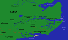
 Map of the River Crouch | |
| Nickname(s) | The Crouch |
| Location | |
| Country | United Kingdom |
| Region | Essex |
| Towns/Villages | Crays Hill, Ramsden Bellhouse, Wickford, Runwell, Battlesbridge, Hullbridge, South Woodham Ferrers, North Fambridge, South Fambridge, Althorne, Creeksea, Burnham-on-Crouch, Basildon |
| Physical characteristics | |
| Source | Springs in The Wilderness woods |
| • location | Near Little Burstead, Billericay, Essex |
| • coordinates | 51°36′34″N 00°24′32″E / 51.60944°N 0.40889°E |
| 3rd source | Langdon Hills |
| Mouth | North Sea |
• location | Between Holliwell Point and Foulness Point |
• coordinates | 51°37′36″N 00°56′21″E / 51.62667°N 0.93917°E |
• elevation | 0 ft (0 m) |
| Length | 28 mi (45 km), West-east |
| Basin features | |
| Tributaries | |
| • left | Fenn Creek, Clementsgreen Creek, Stow Creek, Bridgemarsh Creek |
| • right | Lion Creek, River Roach |
| Designation | |
| Official name | Crouch & Roach Estuaries |
| Designated | 24 March 1995 |
| Reference no. | 721[1] |
River Crouch | |||||||||||||||||||||||||||||||||||||||||||||||||||||||||||||||||||||||||||||||||||||||||||||||||||||||||||||||||||||||||||||||||||||||||||||||||||||||||||||||||||||||||||||||||||||||||||||||||||||||||||||||||||||||||||||||||||||||||||||||||||||||||||||||||||||||||||||||||||||||||||||||||||||||||||||||||||||||||||||||||||||||||||||||||||||||||||||||||||||
|---|---|---|---|---|---|---|---|---|---|---|---|---|---|---|---|---|---|---|---|---|---|---|---|---|---|---|---|---|---|---|---|---|---|---|---|---|---|---|---|---|---|---|---|---|---|---|---|---|---|---|---|---|---|---|---|---|---|---|---|---|---|---|---|---|---|---|---|---|---|---|---|---|---|---|---|---|---|---|---|---|---|---|---|---|---|---|---|---|---|---|---|---|---|---|---|---|---|---|---|---|---|---|---|---|---|---|---|---|---|---|---|---|---|---|---|---|---|---|---|---|---|---|---|---|---|---|---|---|---|---|---|---|---|---|---|---|---|---|---|---|---|---|---|---|---|---|---|---|---|---|---|---|---|---|---|---|---|---|---|---|---|---|---|---|---|---|---|---|---|---|---|---|---|---|---|---|---|---|---|---|---|---|---|---|---|---|---|---|---|---|---|---|---|---|---|---|---|---|---|---|---|---|---|---|---|---|---|---|---|---|---|---|---|---|---|---|---|---|---|---|---|---|---|---|---|---|---|---|---|---|---|---|---|---|---|---|---|---|---|---|---|---|---|---|---|---|---|---|---|---|---|---|---|---|---|---|---|---|---|---|---|---|---|---|---|---|---|---|---|---|---|---|---|---|---|---|---|---|---|---|---|---|---|---|---|---|---|---|---|---|---|---|---|---|---|---|---|---|---|---|---|---|---|---|---|---|---|---|---|---|---|---|---|---|---|---|---|---|---|---|---|---|---|---|---|---|---|---|---|---|---|---|---|---|---|---|---|---|---|---|---|---|---|---|---|---|---|---|---|---|---|---|---|---|---|---|---|
| |||||||||||||||||||||||||||||||||||||||||||||||||||||||||||||||||||||||||||||||||||||||||||||||||||||||||||||||||||||||||||||||||||||||||||||||||||||||||||||||||||||||||||||||||||||||||||||||||||||||||||||||||||||||||||||||||||||||||||||||||||||||||||||||||||||||||||||||||||||||||||||||||||||||||||||||||||||||||||||||||||||||||||||||||||||||||||||||||||||
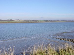
The River Crouch is a small river that flows entirely through the English county of Essex.
The distance of the Navigation between Holliwell Point which is north of Foulness Island and Battlesbridge is 17.5 Miles, i.e. 15.21 Nautical Miles.
- ^ "Crouch & Roach Estuaries". Ramsar Sites Information Service. Retrieved 25 April 2018.