| River Ryton | |
|---|---|
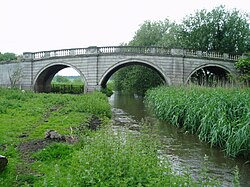
 The Grade I listed Blyth New Bridge carries the A634 over the river. | |
 | |
| Location | |
| Country | England |
| Physical characteristics | |
| Source | |
| • location | Several streams near Lindrick Common |
| • elevation | 260 feet (79 m) |
| Mouth | |
• location | River Idle, Bawtry |
• coordinates | 53°25′19″N 1°00′44″W / 53.421976°N 1.012153°W |
• elevation | 10 feet (3.0 m) |
| Length | 21 miles (34 km) |
| Basin features | |
| Tributaries | |
| • left | Anston Brook, Oldcotes Dyke |
| • right | Pudding Dyke, Bondhay Dyke |
The River Ryton is a tributary of the River Idle. It rises close to the Chesterfield Canal near Kiveton Park, and is joined by a series of tributaries near Lindrick Common in the Metropolitan Borough of Rotherham, South Yorkshire, England. Most of its course is in Nottinghamshire, flowing through the town of Worksop. It meanders northwards to join the River Idle near the town of Bawtry on the South Yorkshire-Nottinghamshire border.
While much of its route is rural, its course through Worksop is man made, a result of development and milling. It used to flow through Scrooby, where there was a mill, but was diverted northwards in the 1960s. It supplies water to the Chesterfield Canal through two feeders, and a number of the bridges which cross it are of interest architecturally, which has resulted in them becoming Listed structures.
The water quality of the river is moderate, as a considerable proportion of the total flow is supplied by the processed water from sewage treatment works. Despite this, there are significant populations of fish in the river, and it is used for organised angling.