| River Till | |
|---|---|
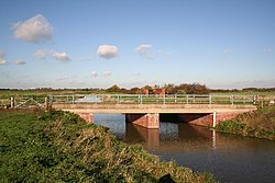
 The bridge carrying Broxholme Lane over the River Till | |
 | |
| Location | |
| Country | England |
| Counties | Lincolnshire |
| Physical characteristics | |
| Source | |
| • location | Corringham |
| • elevation | 66 ft (20 m) |
| Mouth | |
• location | Brayford Pool, Lincoln |
• coordinates | 53°13′48″N 0°32′56″W / 53.2300°N 0.5488°W |
• elevation | 13 ft (4.0 m) |
The River Till is a river in the county of Lincolnshire in England and is ultimately a tributary of the River Witham. Its upper reaches drain the land east of Gainsborough.[1] The middle section is embanked, as the water level is higher than that of the surrounding land, and pumping stations pump water from low level drainage ditches into the river. Its lower reaches from the hamlet of Odder near Saxilby into the city of Lincoln were canalised, possibly as early as Roman times, as part of the Foss Dyke.[2]
Much of the channel is managed by the Environment Agency as it is classified as a main river, while the upper river and the land drainage ditches which border the river are managed by the Upper Witham internal drainage board. In order the help protect the city of Lincoln from flooding, a sluice has been built across the channel at the Till Washlands site. When flooding is a possibility, the sluice is closed, and other sluices allow the surrounding farmland to be inundated until water levels start to fall again. The defences were first used in 2000, and successfully prevented flood damage in Lincoln in the summer of 2007.
There are issues with water quality on much of the river, caused by run-off from agricultural land, physical modification of the river channel, and discharges from sewage treatment works. In 2011, a stretch of the river near Saxilby was affected by the invasive aquatic fern Azolla. An environmental project to control the fern saw some 8,000 Azolla weevils (Stenopelmus rufinasus) released into the river. As they feed exclusively on the fern, once the fern has been consumed they die out naturally without affecting native species.
- ^ Agency 2014, p. 45.
- ^ "Saxilby Village History". Saxilby with Ingleby Parish Council. Archived from the original on 23 July 2018. Retrieved 23 July 2018.