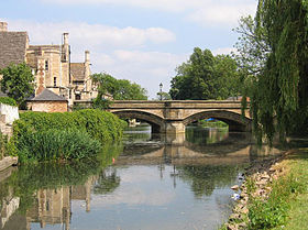
| River Welland | |
|---|---|
 The river at Stamford | |
 | |
| Location | |
| Country | United Kingdom |
| Country within the UK | England |
| Counties | Cambridgeshire, Northamptonshire, Leicestershire, Rutland, Lincolnshire |
| Towns | Market Harborough, Stamford, Crowland, Spalding |
| Physical characteristics | |
| Source | |
| • location | Hothorpe Hills, Sibbertoft, Northamptonshire |
| • coordinates | 52°26′24″N 1°00′35″W / 52.4399°N 1.0098°W |
| • elevation | 157 m (515 ft) |
| Mouth | Fosdyke Wash[3] |
• location | The Wash, Lincolnshire |
• coordinates | 52°53′54″N 0°01′51″E / 52.8983°N 0.0308°E |
• elevation | 1 m (3 ft 3 in) |
| Length | 105 km (65 mi) |
| Basin size | 1,580 km2 (610 sq mi) |
| Discharge | |
| • location | Tallington[1] |
| • average | 3.7 m3/s (130 cu ft/s)[1] |
| • maximum | 94.5 m3/s (3,340 cu ft/s)[2] |
| Basin features | |
| Tributaries | |
| • left | Eye Brook, River Chater, River Gwash, River Glen |
| • right | River Jordan |
| Progression: Welland – The Wash – North Sea | |
The River Welland is a lowland river in the east of England, some 65 miles (105 km) long. It drains part of the Midlands eastwards to The Wash. The river rises in the Hothorpe Hills, at Sibbertoft in Northamptonshire, then flows generally northeast to Market Harborough, Stamford and Spalding, to reach The Wash near Fosdyke. It is a major waterway across the part of the Fens called South Holland, and is one of the Fenland rivers that were laid out with washlands. There are two channels between widely spaced embankments with the intention that flood waters would have space in which to spread while the tide in the estuary prevented free egress. However, after the floods of 1947, new works such as the Coronation Channel were constructed to control flooding in Spalding, and the washlands are no longer used solely as pasture, but may be used for arable farming.
Significant improvements were made to the river in the 1660s, when a new cut with 10 locks was constructed between Stamford and Market Deeping, and two locks were built on the river section below Market Deeping. The canal section was known as the Stamford Canal, and was the longest canal with locks in Britain when it was built. The river provided the final outlet to the sea for land drainage schemes implemented in the seventeenth century, although they were not completely successful until a steam-powered pumping station was built at Pode Hole in 1827. Navigation on the upper river, including the Stamford Canal, had ceased by 1863, but Spalding remained an active port until the end of the Second World War.
The Environment Agency is the navigation authority for the river, which is navigable as far upstream as Crowland, and with very shallow draught to West Deeping Bridge, where further progress is hindered by the derelict lock around the weir. The traditional head of navigation was Wharf Road in Stamford.[4] The management of the lower river has been intimately tied up with the drainage of Deeping Fen, and the river remains important to the Welland and Deepings Internal Drainage Board,[5] for whom it provides the final conduit to the sea for pumped water.
Wildlife in the river varies along its length, the faster headwaters being a habitat for trout and the slower lower reaches for perch. The estuary conditions and flat landscapes beyond Fosdyke favour wading birds and migratory species.
- ^ a b "31004-Welland at Tallington". The National River Flow Archive. Centre for Ecology & Hydrology. Archived from the original on 9 June 2015. Retrieved 24 May 2013.
- ^ "HiFlows-UK AMAX for Tallington Total". Environment-agency.gov.uk. Retrieved 24 May 2013.
- ^ "Fosdyke Wash". Europe / United Kingdom (London) / United Kingdom (general). Get-a-map independent web site. Retrieved 2 June 2013.
- ^ Historic England. "Summary of Navigation on the River Welland (1341736)". Research records (formerly PastScape). Retrieved 26 April 2015.
- ^ "Welland and Deepings IDB".