Riverhead | |
|---|---|
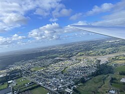
 Riverhead seen from a glider at 1201 feet | |
 | |
| Coordinates: 36°45′29″S 174°35′31″E / 36.758°S 174.592°E | |
| Country | New Zealand |
| Region | Auckland Region |
| Ward | Rodney ward |
| Local board | Rodney Local Board |
| Subdivision | Kumeū subdivision |
| Electorates | |
| Government | |
| • Territorial Authority | Auckland Council |
| Area | |
| • Total | 2.16 km2 (0.83 sq mi) |
| Population (June 2024)[2] | |
| • Total | 3,700 |
| • Density | 1,700/km2 (4,400/sq mi) |
| Postcode | 0820 |
Riverhead is a small, historically predominantly working-class town located at the head of the Waitematā Harbour in the north-west of Auckland, New Zealand. It is located on the northwestern shores of the Upper Waitematā Harbour, north-east of the towns of Kumeū and Huapai.
Traditionally known as Rangitōpuni, the area was an important transportation link for Tāmaki Māori, due to Te Tōangaroa, a portage where waka could be hauled between the Kaipara Harbour and the Waitematā Harbour. European settlement began in 1844 when a kauri mill was established at Riverhead, and the settlement became an important port for reaching the Kaipara Harbour from the 1850s. Riverhead developed as a community in the 1860s around the mill, which had been converted into the largest flour mill in the wider Auckland area. In 1874, a railway between Kumeū and Riverhead along the route of the Te Tōangaroa portage, which helped develop Riverhead and the Kumeū River valley areas, and closed in 1881 when a direct railway between Helensville and Auckland bypassed Riverhead.
Riverhead became an important centre for the kauri gum trade from the 1880s until the early 20th century, and in 1927, an exotic Pinus radiata forest called the Riverhead Forest was established to the north of the town.
- ^ Cite error: The named reference
Areawas invoked but never defined (see the help page). - ^ "Aotearoa Data Explorer". Statistics New Zealand. Retrieved 26 October 2024.