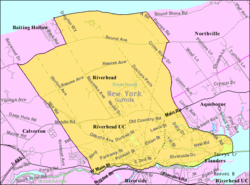
Riverhead, New York | |
|---|---|
 | |
 | |
| Coordinates: 40°55′42″N 72°39′44″W / 40.92833°N 72.66222°W | |
| Country | |
| State | |
| County | Suffolk |
| Town | Riverhead |
| Area | |
| • Total | 16.83 sq mi (43.58 km2) |
| • Land | 15.09 sq mi (39.09 km2) |
| • Water | 1.73 sq mi (4.49 km2) |
| Elevation | 13 ft (4 m) |
| Population (2020) | |
| • Total | 14,993 |
| • Density | 993.37/sq mi (383.54/km2) |
| Time zone | UTC-5 (Eastern (EST)) |
| • Summer (DST) | UTC-4 (EDT) |
| ZIP code | 11901 |
| Area code(s) | 631, 934 |
| FIPS code | 36-61973 |
| GNIS feature ID | 0962565 |
Riverhead is a census-designated place (CDP) roughly corresponding to the hamlet by the same name located in the Town of Riverhead in Suffolk County, on Long Island, in New York, United States. The CDP's population was 13,299 at the 2010 census.[2]
Situated at the mouth of the Peconic River, which empties into Peconic Bay where the North and South Forks of Long Island split, the town of Riverhead (of which the CDP is a part) is the official county seat of Suffolk County. In the 1960s, most of the county offices moved to the CDP of Hauppauge in the towns of Islip and Smithtown in the more populous western half of the county—a move which still spurs attempts for the town of Riverhead to lead the way for the secession of eastern Long Island towns to form Peconic County.
- ^ "ArcGIS REST Services Directory". United States Census Bureau. Retrieved September 20, 2022.
- ^ "U.S. Census website". United States Census Bureau. Retrieved January 31, 2008.

