This article needs additional citations for verification. (December 2021) |


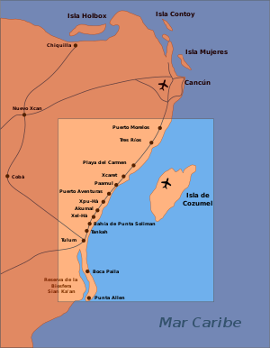
The Riviera Maya (Spanish pronunciation: [ri'βjeɾa 'maʝa]) is a tourism and resort district south of Cancun, Mexico. It straddles the coastal Federal Highway 307, along the Caribbean coastline of the state of Quintana Roo, located in the eastern portion of the Yucatán Peninsula. Originally the name applied narrowly, focusing on the area of coastline between the city of Playa del Carmen and Tulum. The designation has since expanded up and down the coast, now including the towns of Puerto Morelos, situated to the north of Playa del Carmen, as well as the town of Felipe Carrillo Puerto, situated 40 km (25 mi) to the south of Tulum. This larger region is what is currently being promoted as part of the Riviera Maya tourist corridor.
Once the area was originally only called the "Cancun–Tulum corridor", but in 1999 it was renamed as the Riviera Maya, analogous to the Italian and French Riviera, with the instigation of among others, Miguel Ramón Martín Azueta.[1] At the time, he was the municipal president of Solidaridad, Quintana Roo. The Riviera Maya includes the municipalities of Solidaridad in the north and Tulum in the south, and extends approximately 40 km (25 mi) inland, to the border with the state of Yucatán.
- ^ Gollan, Doug (10 October 2015). "Riviera Maya's Tourism Growth Focuses on Luxury, Sustainability While Seeking To Improve Local Life". Forbes. Retrieved 16 June 2017.