Rocheport, Missouri | |
|---|---|
| City of Rocheport | |
 Rocheport, Missouri in 2018 | |
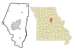
 Location of Rocheport, Missouri | |
| Coordinates: 38°58′42″N 92°33′48″W / 38.97833°N 92.56333°W | |
| Country | United States |
| State | Missouri |
| County | Boone |
| Area | |
| • Total | 0.32 sq mi (0.82 km2) |
| • Land | 0.32 sq mi (0.82 km2) |
| • Water | 0.00 sq mi (0.00 km2) |
| Elevation | 594 ft (181 m) |
| Population (2020) | |
| • Total | 201 |
| • Density | 634.07/sq mi (244.93/km2) |
| Time zone | UTC-6 (Central (CST)) |
| • Summer (DST) | UTC-5 (CDT) |
| ZIP code | 65279 |
| Area code | 573 |
| FIPS code | 29-62498[3] |
| GNIS feature ID | 2396393[2] |
| Website | https://rocheport.com/ |
Rocheport is a city in Boone County, Missouri, United States. It is part of the Columbia, Missouri Metropolitan Statistical Area. The population was 201 at the 2020 census. Rocheport includes the Rocheport Historic District, an area with buildings dating from 1830 and which is listed on the National Register of Historic Places.
- ^ "ArcGIS REST Services Directory". United States Census Bureau. Retrieved August 28, 2022.
- ^ a b U.S. Geological Survey Geographic Names Information System: Rocheport, Missouri
- ^ "U.S. Census website". United States Census Bureau. Retrieved January 31, 2008.