Rochfortbridge
Irish: Droichead Chaisleán Loiste | |
|---|---|
Village | |
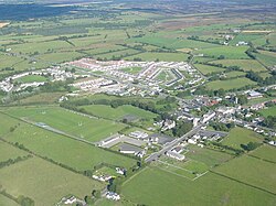
 Aerial view of Rochfortbridge | |
| Coordinates: 53°24′58″N 7°17′46″W / 53.416°N 7.296°W | |
| Country | Ireland |
| Province | Leinster |
| County | County Westmeath |
| Government | |
| • Dáil constituency | Longford–Westmeath |
| • EP constituency | Midlands–North-West |
| Elevation | 32 m (105 ft) |
| Population (2016) | |
| • Urban | 1,473[1] |
| Time zone | UTC+0 (WET) |
| • Summer (DST) | UTC-1 (IST (WEST)) |
| Area code | +353-44-92 |
| Irish Grid Reference | N462407 |
Rochfortbridge (Irish: Droichead Chaisleán Loiste, meaning 'Castle Lost Bridge')[2] is a village in County Westmeath, Ireland. The village is located at the intersection of the R400 and the R446 (formerly the N6) roads. As of the 2016 census, the population of Rochfortbridge was 1,473.[1]
- ^ a b "Sapmap Area - Settlements - Rochfortbridge". Census 2016. CSO. 2016.
- ^ "Droichead Chaisleán Loiste/Rochfortbridge". Placenames Database of Ireland (logainm.ie). Retrieved 18 October 2021.
