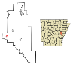
Roe, Arkansas | |
|---|---|
 Location in Monroe County, Arkansas | |
| Coordinates: 34°37′52″N 91°23′09″W / 34.63111°N 91.38583°W | |
| Country | United States |
| State | Arkansas |
| County | Monroe |
| Area | |
| • Total | 0.18 sq mi (0.46 km2) |
| • Land | 0.18 sq mi (0.46 km2) |
| • Water | 0.00 sq mi (0.00 km2) |
| Elevation | 213 ft (65 m) |
| Population | |
| • Total | 68 |
| • Density | 379.89/sq mi (146.91/km2) |
| Time zone | UTC-6 (Central (CST)) |
| • Summer (DST) | UTC-5 (CDT) |
| ZIP code | 72134 |
| Area code | 870 |
| FIPS code | 05-60380 |
| GNIS feature ID | 2407234[2] |
Roe is a town in Monroe County, Arkansas, United States. Located at the junction of U.S. Route 79 and Arkansas Highway 33, the population was 68 at the 2020 census,[3] down from 114 in 2010.
- ^ "2021 U.S. Gazetteer Files: Arkansas". United States Census Bureau. Retrieved June 23, 2022.
- ^ a b U.S. Geological Survey Geographic Names Information System: Roe, Arkansas
- ^ a b "P1. Race – Roe town, Arkansas: 2020 DEC Redistricting Data (PL 94-171)". U.S. Census Bureau. Retrieved June 23, 2022.