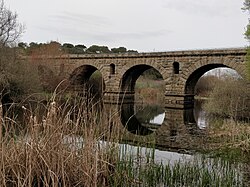
Roman Bridge of Vila Formosa Ponte de Vila Formosa | |
|---|---|
 | |
| Coordinates | 39°12′58″N 7°47′06″W / 39.216°N 7.785°W |
| Crosses | Seda river or stream |
| Locale | Alter do Chão, Portalegre District, |
| Heritage status | Portuguese National Monument |
| Characteristics | |
| Material | Stone |
| Total length | 116.50 metres (382.2 ft) |
| Width | 6.70 metres (22.0 ft) |
| Height | 8.40 metres (27.6 ft) |
| No. of spans | 6 |
| History | |
| Construction start | 1st century CE |
| Location | |
 | |
The Roman Bridge of Vila Formosa (Ponte de Vila Formosa) crosses the Seda stream, close to the village of Seda, in the municipality of Alter do Chão, in the Portalegre District of Portugal. It dates back to the first century CE.[1][2]
- ^ "Ponte de Vila Formosa". Património Cultural. Retrieved 22 March 2022.
- ^ "Ponte romana de Vila Formosa". Terras de Portugal. Retrieved 22 March 2022.