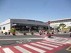
G. B. Pastine Rome Ciampino Airport Aeroporto G. B. Pastine di Roma–Ciampino | |||||||||||||
|---|---|---|---|---|---|---|---|---|---|---|---|---|---|
 | |||||||||||||
 | |||||||||||||
| Summary | |||||||||||||
| Airport type | Public / Military | ||||||||||||
| Owner | Mundys | ||||||||||||
| Operator | Aeroporti di Roma | ||||||||||||
| Serves | Rome metropolitan area / Vatican City | ||||||||||||
| Location | Ciampino, (RM), Italy | ||||||||||||
| Hub for | Ryanair | ||||||||||||
| Elevation AMSL | 427 ft / 130 m | ||||||||||||
| Coordinates | 41°47′58″N 012°35′50″E / 41.79944°N 12.59722°E | ||||||||||||
| Website | www | ||||||||||||
| Map | |||||||||||||
 | |||||||||||||
| Click on the map to see marker | |||||||||||||
| Runways | |||||||||||||
| |||||||||||||
| Statistics (2022) | |||||||||||||
| |||||||||||||
G. B. Pastine–Rome Ciampino Airport (IATA: CIA, ICAO: LIRA) is the secondary international airport serving Rome, the capital of Italy, after Leonardo da Vinci–Rome Fiumicino Airport. It is a joint civilian, commercial and military airport situated 6.5 NM (12.0 km; 7.5 mi) south southeast[1] of central Rome, just outside the Greater Ring Road (Italian: Grande Raccordo Anulare or GRA) the circular motorway around the city.
The airport is an important hub for many low-cost carriers and general aviation traffic. It also hosts a military airport and the headquarters of the 31º Stormo and the 2nd Reparto Genio of the Italian Air Force. The airport is named after Giovan Battista Pastine, an Italian airship pilot who served in World War I.
- ^ a b "EAD Basic - Error Page". www.ead.eurocontrol.int. Archived from the original on 25 February 2009. Retrieved 3 May 2018.
- ^ "Traffic Data 2019" (PDF).