Romeoville, Illinois | |
|---|---|
 Fitzpatrick House (1842), on the grounds of Lewis University | |
| Nickname: "Stone City" | |
| Motto: Where Community Matters! | |
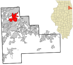
 Location of Romeoville in Will County, Illinois | |
| Country | United States |
| State | Illinois |
| County | Will |
| Township | DuPage, Lockport, Plainfield, Wheatland |
| Incorporated | January 19, 1895 |
| Government | |
| • Mayor | John Noak |
| Area | |
| • Total | 20.16 sq mi (52.21 km2) |
| • Land | 19.13 sq mi (49.55 km2) |
| • Water | 1.03 sq mi (2.67 km2) |
| Elevation | 630 ft (190 m) |
| Population (2020) | |
| • Total | 39,863 |
| • Density | 2,083.80/sq mi (804.58/km2) |
| Time zone | UTC−6 (CST) |
| • Summer (DST) | UTC−5 (CDT) |
| ZIP Code(s) | 60446, 60491 |
| Area codes | 815/779 and 630/331 |
| FIPS code | 17-65442 |
| GNIS feature ID | 2399114[3] |
| Website | http://www.romeoville.org/ |
Romeoville is a village in Will County, Illinois, United States. The village is located 26 mi (42 km) southwest of Chicago on the Gateway Wetlands, directly west of the Des Plaines River. Per the 2020 census, the population was 39,863.[4] It is located in the southwest suburban area of Chicago near Interstate 55 and Interstate 355.
- ^ "2020 U.S. Gazetteer Files". United States Census Bureau. Retrieved March 15, 2022.
- ^ "USGS detail on Newtown". Retrieved October 21, 2007.
- ^ "Village of Romeoville". Geographic Names Information System. United States Geological Survey, United States Department of the Interior.
- ^ "Romeoville village, Illinois". United States Census Bureau. Retrieved April 15, 2022.
