This article needs additional citations for verification. (April 2011) |
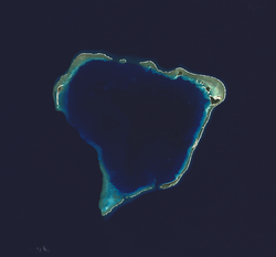
 NASA picture of Rongerik Atoll | |
| Geography | |
|---|---|
| Location | North Pacific |
| Coordinates | 11°20′N 167°27′E / 11.333°N 167.450°E |
| Archipelago | Ralik |
| Total islands | 22 |
| Area | 1.68 km2 (0.65 sq mi) |
| Highest elevation | 3 m (10 ft) |
| Administration | |
| Demographics | |
| Population | 0 |
| Ethnic groups | Marshallese (formerly) |
Rongerik Atoll or Rongdrik Atoll (Marshallese: Ron̄dik, [rʷɔŋʷ(ɯ)rʲik][1]) is an unpopulated coral atoll of 17 islands in the Pacific Ocean, and is located in the Ralik Chain of the Marshall Islands, approximately 200 kilometers (120 mi) east of Bikini Atoll. Its total land area is only 1.68 square kilometers (0.65 sq mi), but it encloses a lagoon of 144 square kilometers (56 sq mi).
In 1946, Rongerik was briefly inhabited by Bikini Islanders who, working with United States Navy moved here temporarily, when Bikini was used for conducting nuclear tests. However, the islanders could not get enough food to support the population, so after two years they had to relocate again, choosing Kili Island.
Politically it was annexed by the German Empire in 1885, then seized by the Japanese in WW1, then the United States took it during WW2. After WW2, it was part of a United Nations trust territory, eventually it became part of the Marshall Islands, an island nation founded in 1986, but with a compact of association with the United States.
