Rosenhayn, New Jersey | |
|---|---|
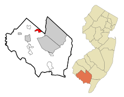
 Map of Rosenhayn highlighted within Cumberland County. Right: Location of Cumberland County in New Jersey. | |
Location in Cumberland County Location in New Jersey | |
| Coordinates: 39°28′43″N 75°08′16″W / 39.47868°N 75.13791°W | |
| Country | |
| State | |
| County | Cumberland |
| Township | Deerfield |
| Area | |
• Total | 2.65 sq mi (6.86 km2) |
| • Land | 2.65 sq mi (6.86 km2) |
| • Water | 0.00 sq mi (0.00 km2) 0.00% |
| Elevation | 108 ft (33 m) |
| Population | |
• Total | 1,150 |
| • Density | 434.45/sq mi (167.74/km2) |
| Time zone | UTC−05:00 (Eastern (EST)) |
| • Summer (DST) | UTC−04:00 (EDT) |
| ZIP Code | 08352 |
| Area code | 856 |
| FIPS code | 34-64740[4][5] |
| GNIS feature ID | 02389778[6] |
Rosenhayn is an unincorporated community and census-designated place (CDP) located within Deerfield Township, in Cumberland County, in the U.S. state of New Jersey.[7] It is part of the Vineland-Millville- Bridgeton Primary Metropolitan Statistical Area for statistical purposes. As of the 2010 United States Census, the CDP's population was 1,098.[8]
Rosenhayn was founded as a Jewish agricultural colony and the 1898 Rosenhayn synagogue is one of the fewer than 100 surviving nineteenth century synagogue buildings in the United States.[9]
- ^ "ArcGIS REST Services Directory". United States Census Bureau. Retrieved October 11, 2022.
- ^ U.S. Geological Survey Geographic Names Information System: Rosenhayn Census Designated Place, Geographic Names Information System. Accessed November 2, 2012.
- ^ Cite error: The named reference
USCensusDecennial2020CenPopScriptOnlywas invoked but never defined (see the help page). - ^ U.S. Census website, United States Census Bureau. Accessed September 4, 2014.
- ^ Geographic Codes Lookup for New Jersey, Missouri Census Data Center. Accessed June 9, 2023.
- ^ US Board on Geographic Names, United States Geological Survey. Accessed September 4, 2014.
- ^ Locality Search, State of New Jersey. Accessed April 19, 2015.
- ^ DP-1 - Profile of General Population and Housing Characteristics: 2010 Demographic Profile Data for Rosenhayn CDP, New Jersey, United States Census Bureau. Accessed November 2, 2012.
- ^ Mark W. Gordon, "Recovering Jewish Infrastructure: Update on 19th Century Synagogues", American Jewish History, 84.1, pages 11-27. 2019 article update.


