This article needs additional citations for verification. (February 2011) |
| Rothwell | |
|---|---|
 | |
Location within West Yorkshire | |
| Population | 20,354 (ward. 2011) |
| OS grid reference | SE345281 |
| Metropolitan borough | |
| Metropolitan county | |
| Region | |
| Country | England |
| Sovereign state | United Kingdom |
| Post town | LEEDS |
| Postcode district | LS26 |
| Dialling code | 0113 |
| Police | West Yorkshire |
| Fire | West Yorkshire |
| Ambulance | Yorkshire |
| UK Parliament | |
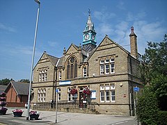
Rothwell is a town in the south-east of the City of Leeds metropolitan borough in West Yorkshire, England,[1] situated between Leeds and Wakefield. It is located in the eponymous Rothwell ward of Leeds City Council and Elmet and Rothwell parliamentary constituency, and is part of the West Yorkshire Urban Area.
At the 2011 census the ward had a population of 20,354.[2] As of the 2021 census, Rothwell has a population of 20,600.[3] The town is close to the A1/M1 link road and the Stourton park and ride. The nearest railway station is Woodlesford.
- ^ "ArcGIS Web Application". leedscc.maps.arcgis.com. Retrieved 10 September 2020.
- ^ "City of Leeds Ward population 2011". Neighbourhood Statistics. Office for National Statistics. Retrieved 29 February 2016.
- ^ "Build a custom area profile – Census 2021, ONS". www.ons.gov.uk. Retrieved 24 September 2024.

