This article has multiple issues. Please help improve it or discuss these issues on the talk page. (Learn how and when to remove these messages)
|
| Rouge National Urban Park | |
|---|---|
IUCN category V (protected landscape/seascape)[1] | |
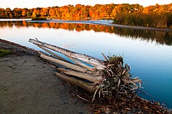
 The Rouge Pond, near the mouth of the Rouge River, at Rouge National Urban Park | |
| Location | Greater Toronto, Ontario, Canada |
| Coordinates | 43°48′30″N 79°09′00″W / 43.8083°N 79.15°W |
| Area | 75 km2 (29 sq mi) |
| Created | May 15, 2015 |
| Operator | Parks Canada |
| Website | www |
 | |
Rouge National Urban Park is a national urban park in Ontario, Canada. The park is centred around the Rouge River and its tributaries in the Greater Toronto Area. The southern portion of the park is situated around the mouth of the river in Toronto, and extends northwards into Markham, Pickering, Uxbridge, and Whitchurch-Stouffville.
Since 2011, Parks Canada has been working to nationalize and nearly double the size of the original Rouge Park.[2] Parks Canada is planning to add more trails, education and orientation centres and improved signage and interpretive panels and displays throughout the park. Parks Canada introduced new educational programs to the park, including Learn-to-Camp, Learn-to-Hike, fire side chats, and other complimentary programming. Once fully established, the park will span 79.1 square kilometres (30.5 sq mi) or approximately 19,500 acres. Parks Canada managed 95% of the area as of June 15, 2019,[3] with the rest expected to be transferred in the future, of which 46 square kilometres (18 sq mi) had been formally designated under the Rouge Urban National Park Act.[4]
- ^ "Protected Planet | Rouge National Urban Park". Protected Planet. Retrieved 2020-10-13.
- ^ Benzie, Robert (25 May 2012). "Parks Canada announces funding for Rouge National Urban Park in the Greater Toronto Area". Toronto Star. Archived from the original on 28 January 2015. Retrieved 19 January 2015.
- ^ "Rouge National Urban Park now 95% complete". Park Canada. Retrieved 2021-04-07.
- ^ Order Amending the Schedule to the Rouge National Urban Park Act: SOR/2019-39, Canada Gazette, 2019-01-31, retrieved 2019-04-11


