Rural Municipality of La Broquerie
Municipalité rurale de La Broquerie | |
|---|---|
Rural municipality | |
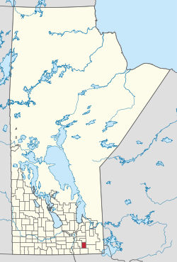
 Location of the RM of La Broquerie in Manitoba | |
| Coordinates: 49°23′58″N 96°30′37″W / 49.39944°N 96.51028°W | |
| Country | Canada |
| Province | Manitoba |
| Region | Eastman |
| Government | |
| • MP (Provencher) | Ted Falk (CPC) |
| • MLA (La Verendrye) | Konrad Narth (PC) |
| • Reeve | Ivan Normandeau |
| Area | |
| • Total | 578.97 km2 (223.54 sq mi) |
| • Water | 9.0 km2 (3.5 sq mi) |
| Elevation | 268 m (879 ft) |
| Population | |
| • Total | 6,725 |
| Time zone | UTC-6 (CST) |
| • Summer (DST) | UTC-5 (CDT) |
| Website | http://www.labroquerie.com/ |
La Broquerie (French: Municipalité rurale de La Broquerie) is a rural municipality in the province of southern Manitoba, located just southeast of the city of Steinbach.
The municipality includes the local urban district of La Broquerie to the north, and the unincorporated communities of Marchand to the east and Zhoda to the south form the urban centres of the municipality.[2][3] Besides these areas, the municipality mainly consists of agricultural production and rural residential developments in the northern half to hog production facilities and vastly undeveloped areas in the south.
- ^ "Population and dwelling counts: Canada, provinces and territories, and census subdivisions (municipalities), Manitoba". Statistics Canada. February 9, 2022. Retrieved February 20, 2022.
- ^ "Manitoba Communities: La Broquerie (Rural Municipality)". www.mhs.mb.ca. Retrieved April 2, 2024.
- ^ "Zoning Map of the Rural Municipality of La Broquerie." RM of La Broquerie. July 2018.