Lac Du Bonnet | |
|---|---|
Rural municipality | |
| Rural Municipality of Lac Du Bonnet | |
 Aerial view of RM Lac du Bonnet | |
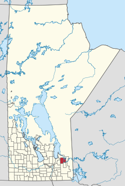
 Location of the Rural Municipality of Lac du Bonnet in Manitoba | |
| Coordinates: 50°14′18″N 96°04′32″W / 50.23833°N 96.07556°W | |
| Country | Canada |
| Province | Manitoba |
| Region | Eastman |
| Census division | 1 |
| Incorporated | 1917 |
| Government | |
| • Reeve | Loren Schinkel |
| Area | |
| • Land | 1,097.61 km2 (423.79 sq mi) |
| Population | |
• Total | 3,563 |
| • Density | 2.8/km2 (7/sq mi) |
| Website | rmoflacdubonnet |
Lac du Bonnet is a rural municipality in the province of Manitoba in Western Canada, situated between the Nopiming Provincial Park to the northeast and Whiteshell Provincial Park to the southeast.
The separately-administered town of Lac du Bonnet lies within the borders of the municipality. It also mostly encircles the Pinawa local government district in the municipality's southeast part. A large portion of the municipality includes waters of the Winnipeg River and its tributaries.[2]
The RM contains the southern part of Manitoba's Brightstone Sand Hills Provincial Forest and the northern part of Agassiz Provincial Forest, although most of these forests lie in other RMs.
- ^ "Population and dwelling counts: Canada, provinces and territories, and census subdivisions (municipalities), Manitoba". Statistics Canada. February 9, 2022. Retrieved February 20, 2022.
- ^ "History of the Rural Municipality of Lac du Bonnet". www.rmoflacdubonnet.com. Retrieved August 7, 2021.