Shamrock No. 134 | |
|---|---|
| Rural Municipality of Shamrock No. 134 | |
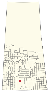
 Location of the RM of Shamrock No. 134 in Saskatchewan | |
| Coordinates: 50°10′05″N 106°36′54″W / 50.168°N 106.615°W[1] | |
| Country | Canada |
| Province | Saskatchewan |
| Census division | 7 |
| SARM division | 2 |
| Formed[2] | December 9, 1912 |
| Government | |
| • Reeve | Wayne Rud |
| • Governing body | RM of Shamrock No. 134 Council |
| • Administrator | Jody Kennedy |
| • Office location | Shamrock |
| Area (2016)[4] | |
| • Land | 757.52 km2 (292.48 sq mi) |
| Population (2016)[4] | |
| • Total | 205 |
| • Density | 0.3/km2 (0.8/sq mi) |
| Time zone | CST |
| • Summer (DST) | CST |
| Area code(s) | 306 and 639 |
The Rural Municipality of Shamrock No. 134 (2016 population: 205) is a rural municipality (RM) in the Canadian province of Saskatchewan within Census Division No. 7 and SARM Division No. 2. Located in the south-central portion of the province, it is south of Highway 1 (the Trans-Canada Highway).
- ^ "Pre-packaged CSV files - CGN, Canada/Province/Territory (cgn_sk_csv_eng.zip)". Government of Canada. July 24, 2019. Retrieved May 23, 2020.
- ^ Cite error: The named reference
ruralincorpwas invoked but never defined (see the help page). - ^ "Municipality Details: RM of Shamrock No. 134". Government of Saskatchewan. Retrieved May 21, 2020.
- ^ a b Cite error: The named reference
2016censusSKmuniswas invoked but never defined (see the help page).
