Ste. Anne | |
|---|---|
Rural municipality | |
| Rural Municipality of Ste. Anne | |
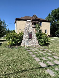
 RM of Ste. Anne Municipal office with Dawson Road monument in front | |
 Location of the RM of Ste. Anne in Manitoba | |
| Coordinates: 49°37′07″N 96°34′15″W / 49.61861°N 96.57083°W | |
| Country | Canada |
| Province | Manitoba |
| Region | Eastman |
| Incorporated | February 1881 |
| Amalgamated | 1890 |
| Re-incorporated | 1908 |
| Named for | Sainte-Anne, New Brunswick |
| Government | |
| • Mayor | Richard Pelletier[1] |
| Area | |
| • Land | 476.81 km2 (184.10 sq mi) |
| Elevation | 263 m (863 ft) |
| Population | |
| • Total | 5,584 |
| • Density | 10.5/km2 (27/sq mi) |
| Time zone | UTC-6 (Central Standard Time) |
| Postal code | R5H |
| Website | rmofsteanne |
Ste. Anne (French: Municipalité rurale de Sainte-Anne) is a rural municipality (RM) in the Eastman Region of Manitoba, Canada, lying southeast of Winnipeg. The separately-administered town of Ste. Anne lies within the geographic borders of the municipality, in its northwestern part.[3]
It includes Paradise Village, a 55-plus retirement community, founded in early 1990, many of whose residents are "snowbirds". The municipality has five privately-owned public golf courses—Cottonwood, Oakwood, Ridgewood, Girouxsalem, and Quarry Oaks—and five privately-owned campgrounds—Lilac, Wild Oaks, Rock Garden, Ridgewood and Cherry Hill.[3]
The municipality is one of the earliest-settled areas of Manitoba.[4]
- ^ "Information". Rural Municipality of Ste. Anne. Retrieved November 23, 2021.
- ^ "Population and dwelling counts: Canada, provinces and territories, and census subdivisions (municipalities), Manitoba". Statistics Canada. February 9, 2022. Retrieved February 20, 2022.
- ^ a b "About the RM of Ste Anne - RM of Ste Anne". www.rmofsteanne.com. Retrieved August 7, 2021.
- ^ "History of the RM of Ste. Anne - RM of Ste Anne". www.rmofsteanne.com. Retrieved August 7, 2021.