| Rysy | |
|---|---|
 Main summit | |
| Highest point | |
| Elevation | 2,501 m (8,205 ft)[1][2] |
| Prominence | 161 m (528 ft)[2] |
| Parent peak | Vysoká |
| Listing | |
| Coordinates | 49°10′46″N 20°5′17″E / 49.17944°N 20.08806°E[2] |
| Naming | |
| English translation | scratches or crevices |
| Language of name | Polish and Slovak |
| Geography | |
| Countries | |
| Parent range | High Tatras |
| Geology | |
| Mountain type | Granite |
| Climbing | |
| First ascent | 1840 by Ede Blásy, Ján Ruman-Driečny[3] |
| Easiest route | Hiking |

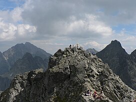
Rysy (Polish: [ˈrɨsɨ] ; Slovak: [ˈrisi]; German: Meeraugspitze, Hungarian: Tengerszem-csúcs) is a mountain in the crest of the High Tatras, eastern part of the Tatra Mountains, lying on the border between Poland and Slovakia. Rysy has three summits: the middle at 2,501 m (8,205 ft); the north-western at 2,500 m (8,202 ft);[4] and the south-eastern at 2,473 m (8,114 ft). The north-western summit is the highest point of Poland and belongs to the Crown of Polish Mountains; the other two summits are on the Slovak side of the border.
- ^ "Topographic map of Rysy". opentopomap.org. Retrieved 2023-07-04.
- ^ a b c "Rysy". Peakbagger.com. Retrieved 2019-04-05.
- ^ Cite error: The named reference
fawas invoked but never defined (see the help page). - ^ "Polskie Rysy ze zmienioną wysokością na nowej mapie Tatr". Onet Podróże (in Polish). 2020-08-23. Archived from the original on 2022-12-22. Retrieved 2023-05-09.


