| Sacramento Mountains | |
|---|---|
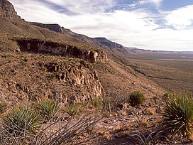
 The western escarpment of the Sacramento Mountains, looking south from Dog Canyon. | |
| Highest point | |
| Peak | Two unnamed areas (Benson Ridge and Corral Canyon) |
| Elevation | 9,695 ft (2,955 m) |
| Coordinates | 32°48′27″N 105°47′59″W / 32.80750°N 105.79972°W |
| Dimensions | |
| Length | 85 mi (137 km) N-S |
| Width | 42 mi (68 km) W-E |
| Geography | |
| Country | United States |
| State | New Mexico |
| Borders on |
|
| Geology | |
| Rock type | Limestone |
The Sacramento Mountains are a mountain range in the south-central part of the U.S. state of New Mexico, lying just east of Alamogordo in Otero County (small portions of the range lie in Lincoln County and Chaves County). From north to south, the Sacramento Mountains extend for 85 miles (137 km), and from east to west they encompass 42 miles (68 km).[1]
- ^ These figures are derived from the official description of the range by the Board on Geographic Names, see the U.S. Geological Survey Geographic Names Information System: Sacramento Mountains (New Mexico) for the range.
