| Safed Koh / Spīn Ghar | |
|---|---|
| Pashto: سپین غر Persian: سفیدکوه Urdu: سفیدکوه | |
 | |
| Highest point | |
| Peak | Mount Sikaram, Afghanistan–Pakistan Border |
| Elevation | 4,755 m (15,600 ft) |
| Coordinates | 33°58′N 70°22′E / 33.967°N 70.367°E |
| Geography | |
 | |
| Countries | Afghanistan and Pakistan |
| Provinces | Nangarhar, Logar, Paktia in Afghanistan and Khyber Pakhtunkhwa in Pakistan |

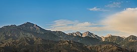
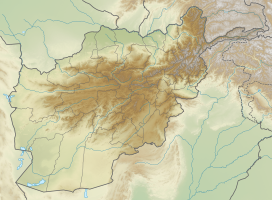
The Spīn Ghar[1][2] (Pashto: سپین غر) or Safēd Kōh[3][4][5] (Dari: سفیدکوه, less used in this area) meaning both White Mountains, or sometimes (Pashto: Selseleh-ye Safīd Kūh[6]) meaning white mountain range, is a mountain range to the south of the Hindu Kush. It ranges from eastern Afghanistan into Khyber Pakhtunkhwa, Pakistan, and forms a natural border between the two areas. Its highest peak is Mount Sikaram on the Afghanistan–Pakistan border, which towers above all surrounding hills to 4,755 m (15,600 ft) above mean sea level.[7] The lower hills are mostly barren and treeless, but pine grows on the main mountains that form the East Afghan montane conifer forests.[citation needed]
- ^ Safīd Mountain Range in Encyclopædia Britannica, 2009
- ^ defect link: CIA document
- ^ Chisholm, Hugh, ed. (1911). . Encyclopædia Britannica. Vol. 23 (11th ed.). Cambridge University Press. pp. 994–995.
- ^ Oxford dictionary, 2014
- ^ Garren, William R., and Carl R. Page. 1987. Gazetteer of Pakistan: official standard names approved by the United States Board on Geographic Names. Washington, D.C.: Congressional Information Service. p.578
- ^ Safīd Mountain Range in: Universalium, 2010
- ^ defense.gov
