Sagadahoc County | |
|---|---|
 | |
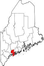
 Location within the U.S. state of Maine | |
 Maine's location within the U.S. | |
| Coordinates: 43°56′58″N 69°51′26″W / 43.949341°N 69.8573°W | |
| Country | |
| State | |
| Founded | February 14, 1854 |
| Named for | Abenaki word meaning "mouth of the big river;"[1] a former name for the Kennebec River |
| Seat | Bath |
| Largest city | Topsham |
| Area | |
| • Total | 370 sq mi (1,000 km2) |
| • Land | 254 sq mi (660 km2) |
| • Water | 116 sq mi (300 km2) 31% |
| Population (2020) | |
| • Total | 36,699 |
| • Density | 99/sq mi (38/km2) |
| Time zone | UTC−5 (Eastern) |
| • Summer (DST) | UTC−4 (EDT) |
| Congressional district | 1st |
| Website | www |
Sagadahoc County (/ˈsæɡədəhɒk/ SAG-ə-də-hok) is a county located in the U.S. state of Maine. As of the 2020 census, the population was 36,699.[2] Its county seat is Bath.[3] In geographic area, it is the smallest county in Maine.
Sagadahoc County is part of the Portland–South Portland, ME Metropolitan Statistical Area.
- ^ "Sagadahoc County".
- ^ "Census - Geography Profile: Sagadahoc County, Maine". United States Census Bureau. Retrieved November 21, 2021.
- ^ "Find a County". National Association of Counties. Retrieved June 7, 2011.
