Saimbeyli
Hadjin • Հաճն | |
|---|---|
District and municipality | |
 Partial view of the town | |
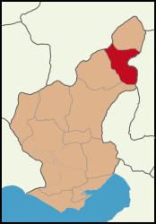
 Map showing Saimbeyli District in Adana Province | |
| Coordinates: 37°59′N 36°05′E / 37.983°N 36.083°E | |
| Country | Turkey |
| Province | Adana |
| Government | |
| • Mayor | Mahmut Dal (AKP) |
| Area | 989 km2 (382 sq mi) |
| Elevation | 1,050 m (3,440 ft) |
| Population (2022)[1] | 13,621 |
| • Density | 14/km2 (36/sq mi) |
| Time zone | UTC+3 (TRT) |
| Postal code | 01740 |
| Area code | 0322 |
| Website | www |
Saimbeyli, historically known as Hadjin (Armenian: Հաճըն, romanized: Hačən), is a town and district of Adana Province in present-day Turkey.[2] Its area is 989 km2,[3] and its population is 13,621 (2022).[1] The town is located at the Taurus mountains of Cilicia region, 157 km north of the city of Adana.
Saimbeyli is perched in a valley between the forested mountains of Dibek and Bakir. There is a pass through the mountains from here to Kayseri and the valley is watered by mountain streams.
It was one of the sites of the 1909 Adana massacres during the Armenian genocide.
- ^ a b "Address-based population registration system (ADNKS) results dated 31 December 2022, Favorite Reports" (XLS). TÜİK. Retrieved 12 July 2023.
- ^ Büyükşehir İlçe Belediyesi, Turkey Civil Administration Departments Inventory. Retrieved 12 July 2023.
- ^ "İl ve İlçe Yüz ölçümleri". General Directorate of Mapping. Retrieved 12 July 2023.
