Saint-Alexis-des-Monts | |
|---|---|
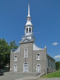
 Saint-Alexis Church | |
| Motto: Progrès et Harmonie | |
 Location within Maskinongé RCM. | |
| Coordinates: 46°28′N 73°08′W / 46.467°N 73.133°W[1] | |
| Country | |
| Province | |
| Region | Mauricie |
| RCM | Maskinongé |
| Settled | 1865 |
| Constituted | April 21, 1984 |
| Government | |
| • Mayor | Michel Bourassa |
| • Federal riding | Berthier—Maskinongé |
| • Prov. riding | Maskinongé |
| Area | |
| • Total | 1,135.80 km2 (438.53 sq mi) |
| • Land | 1,035.74 km2 (399.90 sq mi) |
| Population (2021)[3] | |
| • Total | 2,999 |
| • Density | 2.9/km2 (8/sq mi) |
| • Pop 2016-2021 | |
| • Dwellings | 2,136 |
| Time zone | UTC−5 (EST) |
| • Summer (DST) | UTC−4 (EDT) |
| Postal code(s) | |
| Area code | 819 |
| Highways | |
| Website | www.saint- alexis-des-monts.ca |
Saint-Alexis-des-Monts is a parish municipality in the Mauricie region of the province of Quebec in Canada.
It is located in the Laurentian Mountains, having a topography that is characterized by valleys and rounded hills, with an altitude varying between 150 metres (490 ft) to 560 metres (1,840 ft). There are more than 600 lakes, 400 named and another 200 unnamed minor lakes.[4] The majority (65%) of its territory is part of the Matawin Wildlife Reserve. The town depends on outdoor tourism that increases its seasonal population to between 8000 and 10,000 persons.[5]
- ^ Cite error: The named reference
toponymiewas invoked but never defined (see the help page). - ^ a b Cite error: The named reference
mamrotwas invoked but never defined (see the help page). - ^ a b Cite error: The named reference
cp2021bwas invoked but never defined (see the help page). - ^ "Saint-Alexis-des-Monts en quelques chiffres" (in French). Municipalité de Saint-Alexis-des-Monts. Archived from the original on 2010-01-28. Retrieved 2010-02-08.
- ^ "La Municipalité" (in French). Municipalité de Saint-Alexis-des-Monts. Archived from the original on 2010-01-28. Retrieved 2010-02-08.
