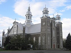
Saint-Cyrille-de-Wendover | |
|---|---|
 | |
 Location within Drummond RCM. | |
| Coordinates: 45°56′N 72°26′W / 45.933°N 72.433°W[1] | |
| Country | |
| Province | |
| Region | Centre-du-Québec |
| RCM | Drummond |
| Constituted | September 6, 1905 |
| Government | |
| • Mayor | Daniel Lafond |
| • Federal riding | Drummond |
| • Prov. riding | Drummond–Bois-Francs |
| Area | |
| • Total | 110.40 km2 (42.63 sq mi) |
| • Land | 110.30 km2 (42.59 sq mi) |
| Population | |
| • Total | 4,389 |
| • Density | 39.8/km2 (103/sq mi) |
| • Pop 2006-2011 | |
| • Dwellings | 1,671 |
| Time zone | UTC−5 (EST) |
| • Summer (DST) | UTC−4 (EDT) |
| Postal code(s) | |
| Area code | 819 |
| Highways | |
| Website | www |
Saint-Cyrille-de-Wendover is a Quebec municipality located in the Drummond Regional County Municipality, just east of Drummondville, in the Centre-du-Quebec region. The population as of the Canada 2011 Census was 4,389. The town is located alongside the Rivière des Saults.
The town, previously known as Saint-Cyrille, was created in 1905. It was merged in 1982 with the townships of Wendover and Simpson to form the current name. Being located in the middle of numerous townships and valleys, the municipality has agriculture as its predominant activity.
- ^ Cite error: The named reference
toponymiewas invoked but never defined (see the help page). - ^ a b "Ministère des Affaires municipales, des Régions et de l'Occupation du territoire: Saint-Cyrille-de-Wendover". Archived from the original on 2012-05-01. Retrieved 2012-03-11.
- ^ Parliament of Canada Federal Riding History: DRUMMOND (Quebec)
- ^ a b 2011 Statistics Canada Census Profile: Saint-Cyrille-de-Wendover, Quebec
