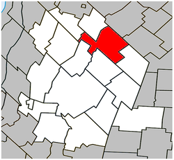
Saint-Hugues | |
|---|---|
 Location within Les Maskoutains RCM. | |
| Coordinates: 45°48′N 72°52′W / 45.800°N 72.867°W[1] | |
| Country | |
| Province | |
| Region | Montérégie |
| RCM | Les Maskoutains |
| Founded | 1827 |
| Constituted | November 6, 1982 |
| Government | |
| • Mayor | Serge Picard |
| • Federal riding | Saint-Hyacinthe—Bagot |
| • Prov. riding | Saint-Hyacinthe |
| Area | |
| • Total | 85.90 km2 (33.17 sq mi) |
| • Land | 83.84 km2 (32.37 sq mi) |
| Population (2011)[4] | |
| • Total | 1,292 |
| • Density | 15.4/km2 (40/sq mi) |
| • Pop 2006-2011 | |
| • Dwellings | 536 |
| Time zone | UTC−5 (EST) |
| • Summer (DST) | UTC−4 (EDT) |
| Postal code(s) | |
| Area code(s) | 450 and 579 |
| Highways | |
| Website | www |
Saint-Hugues (/ ... ˈhjuːz/ ... HEWZ, French: [sɛ̃.yɡ]) is a town in southwestern Quebec north northeast of St-Hyacinthe, with a 2006 population of 1,310. It is located along Quebec Route 224, halfway between Saint-Guillaume and Saint-Simon-de-Bagot.
- ^ Cite error: The named reference
toponymiewas invoked but never defined (see the help page). - ^ a b Ministère des Affaires municipales, des Régions et de l'Occupation du territoire: Saint-Hugues
- ^ Parliament of Canada Federal Riding History: SAINT-HYACINTHE--BAGOT (Quebec)
- ^ a b Cite error: The named reference
cp2011was invoked but never defined (see the help page).
