Saint-Hyacinthe | |
|---|---|
| Ville de Saint-Hyacinthe | |
 Parc Casimir-Dessaules. | |
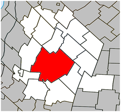
 Location within Les Maskoutains RCM | |
| Coordinates: 45°37′N 72°57′W / 45.617°N 72.950°W[1] | |
| Country | Canada |
| Province | Quebec |
| Region | Montérégie |
| RCM | Les Maskoutains |
| Founded | 1849 |
| Constituted | 27 December 2001 |
| Government | |
| • Mayor | André Beauregard |
| • Federal riding | Saint-Hyacinthe—Bagot |
| • Prov. riding | Saint-Hyacinthe |
| Area | |
| • City | 191.60 km2 (73.98 sq mi) |
| • Land | 188.97 km2 (72.96 sq mi) |
| • Urban | 30.8 km2 (11.9 sq mi) |
| • Metro | 328.53 km2 (126.85 sq mi) |
| Population (2016)[4] | |
| • City | 59,614 |
| • Density | 294.5/km2 (763/sq mi) |
| • Urban | 50,616 |
| • Urban density | 1,643.4/km2 (4,256/sq mi) |
| • Metro | 56,794 |
| • Metro density | 181.5/km2 (470/sq mi) |
| • Pop 2011-2016[4] | |
| • Dwellings[4] | 25,483 |
| Time zone | UTC−05:00 (EST) |
| • Summer (DST) | UTC−04:00 (EDT) |
| Postal code(s) | |
| Area code(s) | 450 and 579 |
| Highways | |
| Website | Official website |
Saint-Hyacinthe (/ ... ˈhaɪ.əsɪnθ/ ... HY-ə-sinth, French: [sɛ̃t‿ijasɛ̃t]) is a city in southwestern Quebec east of Montreal on the Yamaska River. The population as of the 2021 Canadian census was 57,239.[6] The city is located in Les Maskoutains Regional County Municipality of the Montérégie region, and is traversed by the Yamaska River. Quebec Autoroute 20 runs perpendicular to the river. Saint-Hyacinthe is the seat of the judicial district of the same name.[7]
- ^ Cite error: The named reference
toponymiewas invoked but never defined (see the help page). - ^ a b "Saint-Hyacinthe - Répertoire des municipalités - Ministère des Affaires municipales et de l'Occupation du territoire". gouv.qc.ca. Archived from the original on 29 September 2013. Retrieved 16 January 2016.
- ^ "History of Federal Ridings since 1867". parl.gc.ca. Retrieved 16 January 2016.
- ^ a b c d Statistics Canada (9 August 2019). "Census Profile 2016 -Saint-Hyacinthe, Ville [Census subdivision], Quebec and Les Maskoutains, Municipalité régionale de comté [Census division], Quebec". statcan.gc.ca. Retrieved 15 August 2019.
- ^ a b Census Profile, 2016 Census Saint-Hyacinthe [Census agglomeration], Quebec and Quebec [Province]. The census agglomeration consists of Saint-Hyacinthe, Saint-Dominique, Saint-Simon. In the 2006 census, the census agglomeration had not included Saint-Dominique, but had included La Présentation and Saint-Barnabé-Sud.
- ^ Government of Canada, Statistics Canada (9 February 2022). "Profile table, Census Profile, 2021 Census of Population - Saint-Hyacinthe, Ville (V) [Census subdivision], Quebec". www12.statcan.gc.ca. Retrieved 11 October 2022.
- ^ Territorial Division Act. Revised Statutes of Quebec D-11.

