| Saint-Maurice River Tapiskwan sipi | |
|---|---|
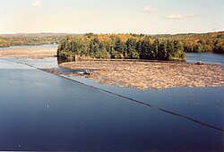
 Timber rafting, Shawinigan, 1994 | |
 | |
| Native name | Rivière Saint-Maurice (French) |
| Location | |
| Country | |
| Province | |
| Region | Mauricie |
| Physical characteristics | |
| Source | Gouin Reservoir |
| • coordinates | 48°21′15″N 74°06′00″W / 48.35417°N 74.10000°W |
| • elevation | 404 m (1,325 ft) |
| Mouth | Saint Lawrence River |
• location | Trois-Rivières |
• coordinates | 46°20′55″N 72°31′40″W / 46.34861°N 72.52778°W |
• elevation | 3 m (9.8 ft) |
| Length | 563 km (350 mi)[1] |
| Basin size | 43,300 km2 (16,700 sq mi)[1] |
| Discharge | |
| • average | 730 m3/s (26,000 cu ft/s) |
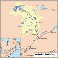
The Saint-Maurice River, or the Saint-Maurice River, is one of the main tributaries of the St. Lawrence River, after the Ottawa and the Saguenay Rivers and drains an area of 42,735 km2. It touches the Lake Saint John watershed to the north; the Nottaway River watershed, a major tributary of James Bay, to the northwest; and the southwestern tributaries of the Ottawa River. The Saint-Maurice River is located on the north shore of the St. Lawrence River in Quebec, Canada.[2]
The main tributaries of the Saint-Maurice River are:
- Matawin River, whose mouth is at Matawin (Hamlet);
- Vermillon River (La Tuque) which empties about 23 km, 14 miles (by water) upstream (north) of the Beaumont generating station in La Tuque;
- Manouane River (La Tuque) which empties about 115 km, 70 miles (by water) upstream (north) of La Tuque;
- La Trenche River (La Tuque) which empties near the La Trenche Generating Station;
- Croche River (La Tuque) which empties at north of La Tuque.
Between Weymontachie and Trois-Rivières, the St-Maurice River has 27 tributaries identified as significant enough for downhill wood:[3] Weymontachingue, Manouane, Little Rock, Little Flamand, Windigo, Flamand, Coucoucache, Grande Pierriche (Great Pierriche), Petite Pierriche (Little Pierriche), "La Trenche", Vermillion, Croche, Rivière-au-Lait, Bostonnais, Little Bostonnais, Small Stream, Mountain, Caribou, Rivière-aux-Rats, Wessonneau, Little Batiscan River, l'Oiseau (Bird), Bête Puante (Beast Puante), Mattawin, Mekinac, River "au Lac des Pêches" and Shawinigan River.
During the 18th century, early fur traders travelled along the river. During the second half of the 19th century, logging became an important industry in the surrounding Mauricie region. For much of the 20th century, the river was used to transport logs to mills down river and it was, and still is, a major source of hydroelectric power.
First communication channel in this region, the river was used by local Native Americans long before the arrival of Europeans on the spot. Early explorations by religious conversion in pain and trappers in search of furs for the trade, it was one of the primary routes of rivers in Quebec.
Several municipalities have been established on its banks, thereby taking advantage of its hydroelectric power where the falls were high enough to install a dam integration an electrical generating station. Among other cities, La Tuque, Shawinigan and Trois-Rivières are the best known, and are themselves located along the Route 155 which connects the St. Lawrence River to Lake St. John.
- ^ a b Natural Resources Canada > Atlas of Canada > Rivers
- ^ "Saint-Maurice River". Commission de Toponymie du Québec (in French). Government of Quebec. 1968-12-05. Retrieved 2023-11-25.
Metaberoutin, is mentioned in the Jesuit Relations in 1635
- ^ Journals of the Legislative Assembly of Canada, 11 (1852).