Saint-Venant-de-Paquette | |
|---|---|
 Saint-Venant-de-Paquette Church | |
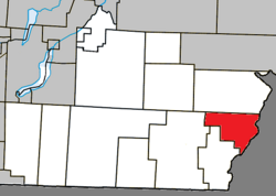
 Location within Coaticook RCM | |
| Coordinates: 45°08′N 71°28′W / 45.133°N 71.467°W[1] | |
| Country | Canada |
| Province | Quebec |
| Region | Estrie |
| RCM | Coaticook |
| Constituted | June 11, 1917 |
| Government | |
| • Mayor | Henri Pariseau |
| • Federal riding | Compton—Stanstead |
| • Prov. riding | Saint-François |
| Area | |
| • Total | 58.60 km2 (22.63 sq mi) |
| • Land | 58.75 km2 (22.68 sq mi) |
| There is an apparent contradiction between two authoritative sources | |
| Population | |
| • Total | 69 |
| • Density | 1.2/km2 (3/sq mi) |
| • Pop 2016-2021 | |
| • Dwellings | 61 |
| Time zone | UTC−5 (EST) |
| • Summer (DST) | UTC−4 (EDT) |
| Postal code(s) | |
| Area code | 819 |
| Highways | |
| Website | municipalites-du-quebec |
Saint-Venant-de-Paquette is a municipality in Quebec, Canada. The village, founded in 1862, is situated north of East-Hereford, south of St. Malo, and east of Coaticook.
